

Low Pressure likely to be formed in next few hours
The India Meteorological Department (IMD) reported on Monday that a low pressure area had formed over the Southeast Bay of Bengal and the adjoining South Andaman Sea.
 user1
user1
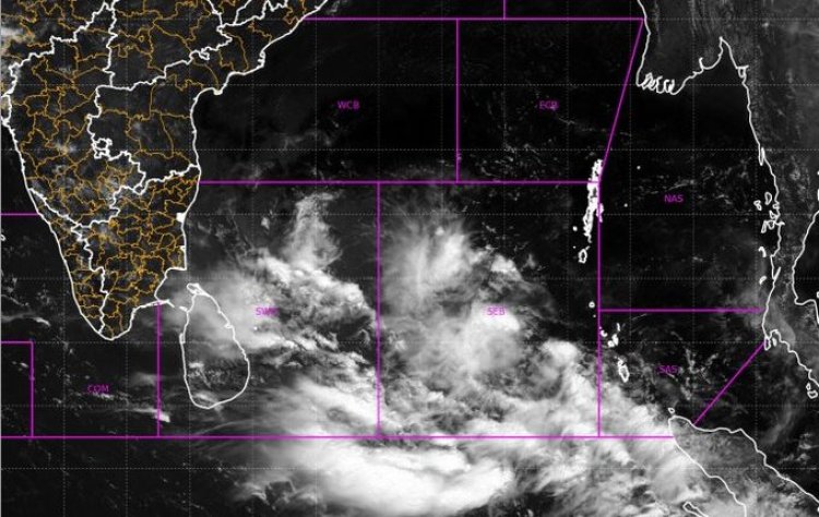
Bhubaneswar: The India Meteorological Department (IMD) reported on Monday that a low pressure area had formed over the Southeast Bay of Bengal and the adjoining South Andaman Sea.
The system is expected to consolidate into a Depression over the same region around May 9 and intensify into a cyclonic storm over the southeast Bay of Bengal and adjoining areas of the East Central Bay of Bengal and the Andaman Sea on May 10. According to the MeT office, it is expected to move north-northwestwards towards the eastcentral Bay of Bengal until May 11 before recurving gradually and moving north-northeastwards towards the Bangladesh-Myanmar coasts.
The cyclonic storm poses no immediate threat, according to the weatherman.
While the MeT office previously stated that details of the cyclone's path and intensification would be provided after the formation of the low pressure area, the European Centre for Medium-Range Weather Forecasts (ECMWF) indicated a change of path and the possible cyclone heading towards Bangladesh coast very close to Indian east coast around May 14-15 instead of Myanmar.
According to the GFS model, the cyclone is changing course and heading towards the border between Bangladesh and Myanmar. According to the most recent forecast, the storm will be at least an ESCS (Cat-4) in intensity.
When it becomes a cyclonic storm, the system will be named Cyclone Mocha, a name suggested by Yemen. It derives from the Yemeni city of Mocha (or Mokha) on the Red Sea coast, which is credited with introducing coffee to the world over 500 years ago. Mocha is a warm chocolate-flavored beverage that is a coffee variant.